The 'Other' Rides... (The MadMap Rides)
Coors Ride - 12 Miles (Round Trip)

Directions: Exit Marriott parking lot to the right. Another right at the light. Cross over I-70 and enter ramp for eastbound I-70. Take next exit (264) - Youngfield/32nd Ave exit turn left at bottom of ramp onto Youngfield. Proceed north a few blocks and turn left (W) on 32nd Ave. Continue west for 4 miles to Coors Visitor Parking lot on left at 13th and Ford St. Tours run every 20 minutes. Open Monday through Saturday, 10 a.m. to 4 p.m., and closed Sundays and holidays. About six miles each way.
DeLorme Street Atlas File
Garmin Mapsource File
Microsoft Streets and Trips File
Microsoft Streets and Trips
Driving Directions.pdf
Red Rocks Ride - 15 Miles

Directions: Upon exiting Marriott lot turn right, then another right at light then right onto westbound I-70. Take next exit (262) onto Colfax (US 40) westbound. Continue west for 1.6 miles then turn left at the light on Rooney Road. Continue south past the MX track to stop sign on Alameda. Turn right on Alameda up the hill, past the dinosaur tracks and geological markers. At stop sign, cross Hogback Road (Hwy 26) and enter Red Rocks Park. Follow winding roads on map through beautiful rock formations and/or go up to marked visitor's center. Return to Hogback Road (Hwy 26) and proceed north to I-70 eastbound. Exit at 263 and back into Marriott.
DeLorme Street Atlas File
Garmin Mapsource File
Microsoft Streets and Trips File
Microsoft Streets and Trips
Driving Directions.pdf
Clearview - Pine Valley Ranch Ride - 90 Miles (Round Trip)
![]()
Directions: Upon exiting Marriott parking lot, take a right then another right to the westbound I-70 ramp. Proceed west on I-70 to exit 259. At the light turn left toward Morrison on SR 26. In 1.3 miles turn right to enter Red Rocks Park. Follow the marked route for 1.8 miles then turn right onto Hwy 74. Proceed west for 5 miles then turn left on Parmalee Gulch Road. Proceed south for 4.3 miles then turn onto US 285 south. AFTER ONLY A QUARTER MILE left onto S. Turkey Creek Rd, marked to Tiny Town. After 1.5 miles rejoin US 285 southbound. Follow 285 south for 12 miles to Pine Junction (traffic light) At this point you can turn right, go about two long blocks to Clearview Shields, grey building with blue roof. Or...turn left onto 126, Pine Valley Road. Proceed SE 5.2 miles and turn right into Pine Valley Ranch Park. Proceed west .8 miles to parking/rest area and end of road. Return same route.
Additional Info: Take your camera! This ride takes you through Red Rocks Park, beautiful rock formations. If you have time have a coffee or latte in the Trading Post, and sit out on the deck. On the upper lot checkout the large visitors center, most interesting. Then takes you through Parmelee Gulch, nice twisties. Also takes you through Tiny Town. This is a town with a detailed miniature town and railroad, lots of Kodak moments. At Pine Junction you have a couple options, or do them both:
You can turn right a couple long blocks to Clearview Shields if you wanted to see any of their products.
Or turn left which takes you down 126 to Pine Valley Ranch. Great twisty road. This is a beautiful Park, free, along the South Platte River and a short walk to a scenic pond. Also has the nicest outhouses in Colorado...
DeLorme Street Atlas File
Garmin Mapsource File
Microsoft Streets and Trips File
Microsoft Streets and Trips Driving
Directions.pdf
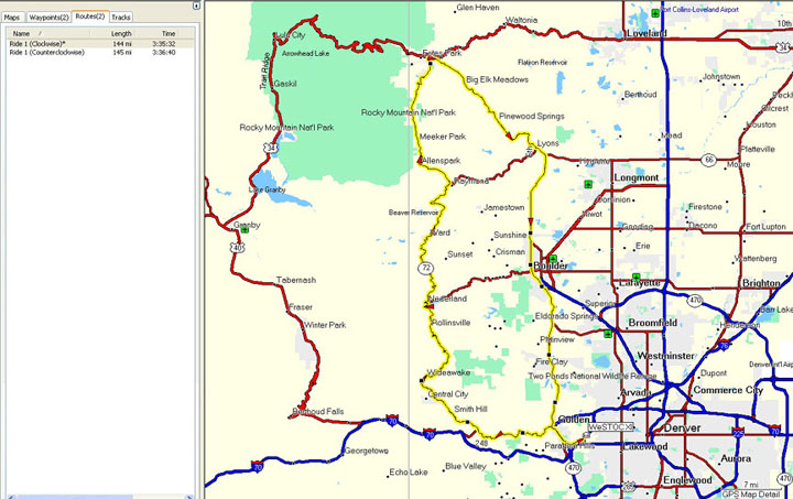
Peak to Peak (and more) - 144 Miles
DeLorme Street Atlas File
Garmin Mapsource File
Microsoft Streets and Trips File
Microsoft Streets and Trips Driving
Directions.pdf
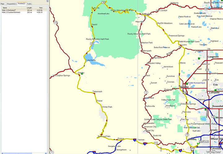
RMNP / Trail Ridge (and more) - 201 Miles
DeLorme Street Atlas File
Garmin Mapsource File
Microsoft Streets and Trips File
Microsoft Streets and Trips Driving
Directions.pdf
Fairplay Loop - 181 Miles

DeLorme Street Atlas File
Garmin Mapsource File
Microsoft Streets and Trips File
Microsoft Streets and Trips Driving
Directions.pdf
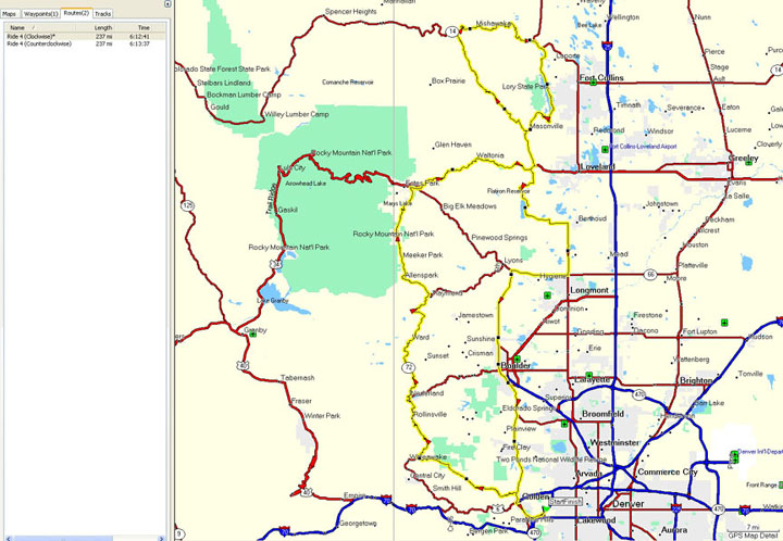
Golden Gate Canyon / Peak-to-Peak North Loop - 237 Miles
DeLorme Street Atlas File
Garmin Mapsource File
Microsoft Streets and Trips File
Microsoft Streets and Trips Driving
Directions.pdf
Mount Evans - 127 Miles

DeLorme Street Atlas File
Garmin Mapsource File
Microsoft Streets and Trips File
Microsoft Streets and Trips Driving
Directions.pdf
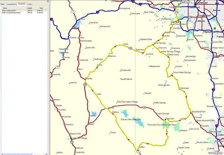
South Park (Pikes Peak area - 245 Miles
DeLorme Street Atlas File
Garmin Mapsource File
Microsoft Streets and Trips File
Microsoft Streets and Trips Driving
Directions.pdf
Single Garmin .gbd file with all these rides
NOTE!!
The GPS routes available above were created using Garmin's Mapsource program and the City Navigator North America v7 map database. This is the
map database that comes with the Garmin 2610 family of gps devices. If you have an earlier version of City Navigator (v6), or if you own a different gps, or use
a different map set with your gps, you must verify these routes before using them!! Due to differences in the various map sets, you <may> get a slightly
different route when using the provided routes!! To verify the route, load it into Mapsource, double click on the desired route in the route list, and select
'recalculate route'. Mapsource will then use the route waypoint data and your map database to create the route. <Sometimes> the route you get can vary from
the desired route due to differences in the various map databases. Carefully compare the route you get with the routes above. If you do see a deviation from the
desired route simply right click on the route and select 'insert route section', then pick a point on the desire road. Mapsource will modify the route to include
that road section. You can then upload the route into your gps.
The verification process is an important step if you are using anything other than a 2610 and the v7 database. Even if you upload these routes into a
different gps and they <look> correct, be wary! The first time the gps <thinks> you're off route it will perform a recalculation of the route
and <may> change the route to <something> different!!