The MadMap Rides... (The 'Other' Rides)

WeSTOC is known for its great riding opportunities. In fact, the
primary decision on where to hold WeSTOC revolves around whether or not
the location has great rides!
WeSTOC XVII is certainly no exception to this rule! If you like tight twisties, monster sweepers, spectacular scenery and huge elevation
changes... this is the place for you!
While you are certainly welcome to do so, it's not necessary to cross
the Continental Divide to find the best rides. The road to Mt. Evans,
the highest paved road in North America at 14,258 feet above sea level,
is less than an hour away. While it does have a number of tight
180-degree switchbacks, it's not a difficult technical ride, even
two-up, but you will still need to pay close attention. Watch out for
the numerous mountain goats and big horn sheep, they seem intrigued by
motorcycles. Fuel-injected bikes will have no problem with the altitude,
nor will the modern carbureted bikes, the latter will just need to
carry a few more RPM's. (If going to Mt. Evans, see note on ride #3,
below)
If you have a valid park service pass (see
here), bring it. Otherwise a
3-day pass is available for just $3 at the entrance. It will also allow
you into Rocky Mountain National Park and Trail Ridge Road, the highest
continuously paved road in North America. There are also deer along all
these roadways...again, pay attention and avoid blind-turn banzai runs.
Trivia: Colorado contains 75% of the land area of the U.S. with an
altitude over 10,000 feet.
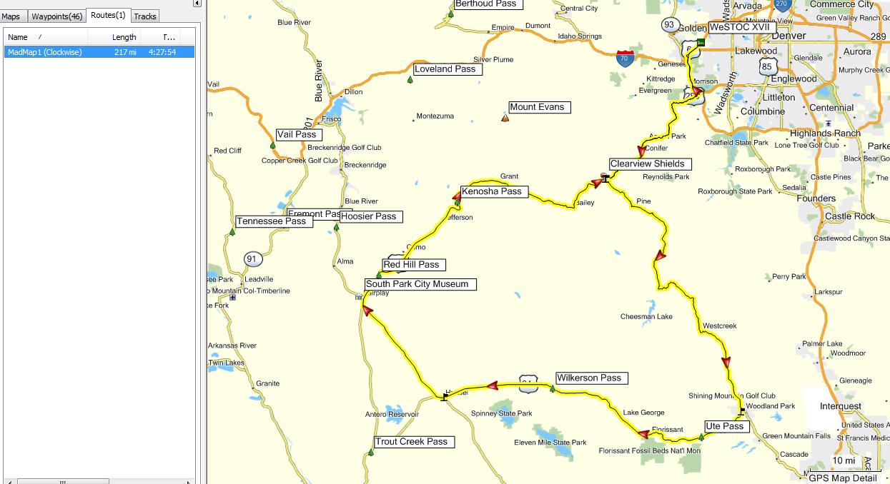
MadMap Ride 1 - America the Beautiful - 217 Miles
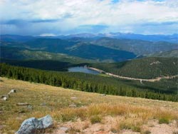 The view from Pikes Peak is said to have been the inspiration for the song, 'America the
Beautiful'.
Enjoy the sweeping panoramas as you circle Pike National Forest and then wind your way along the north for of the South Platte River.
The view from Pikes Peak is said to have been the inspiration for the song, 'America the
Beautiful'.
Enjoy the sweeping panoramas as you circle Pike National Forest and then wind your way along the north for of the South Platte River.
Warnings: Use caution during inclement weather on the portion of the loop between Schaffer Crossing and Sphinx Park; the road is well-graded dirt.
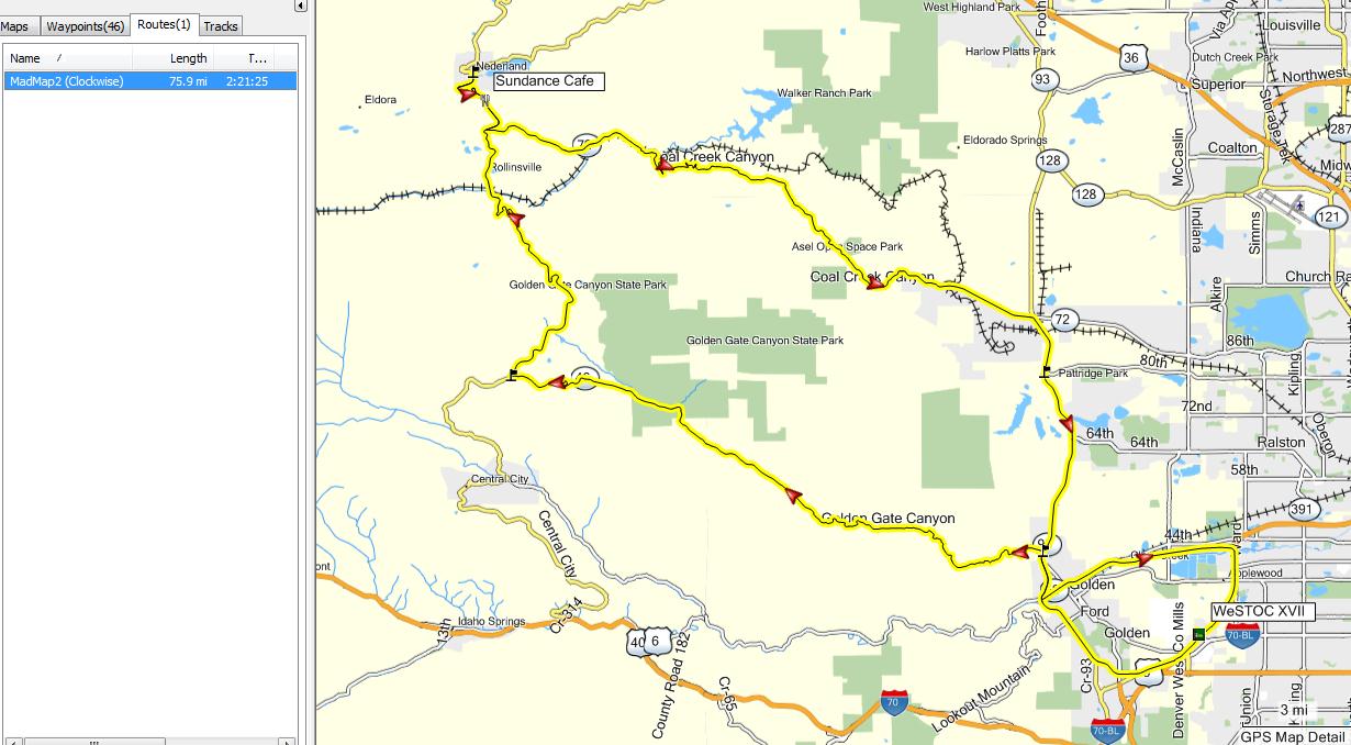
MadMap Ride 2 - Short, Sweet and Sassy - 73 Miles
The memories will linger long after you've finished this short ride, which will whisk you along the winding curves of Coal Creek Canyon and then send you sailing through the sweepers along the Peak to Peak Scenic Byway. The ride winds down to a twisty run through Golden Gate Park. You'll have plenty of time left to tour the Coors Brewery in Golden.
Warnings: Watch for stray wildlife, water, rocks and even ice on the mountain roads; beware of sand and loose gravel along the switchbacks.
Attractions: Enjoy a meal on the deck of the Sundance Cafe and Lodge on the southern outskirts of Nederland or the Wondervue Cafe in Wondervue on Hwy 72 of the return leg. Both places are biker friendly, have good food and indoor/outdoor dining.
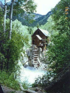
MadMap Ride 3 - Riding High - 106 Miles
(Note: The last 5 miles (of 15) of road to the Mt. Evans summit will be closed for the season starting Tues. 9/4/12, according to CDOT.)
This high altitude loop takes you on a fabulous ride up Bear Creek Canyon and then along the highest paved road in North America. The ride down is a twisty run through the towering peaks lining Clear Creek Canyon. Finish off the adventure with a stop in historic Idaho Springs.
Warnings: Look for signs 'Motorcyclists Use Caution' as you begin up Bear Creek Canyon. Hazards include bicyclists, sand, rocks and some decreasing radius turns.
Attractions: Soothe your aches at the hot springs in Idaho Springs.

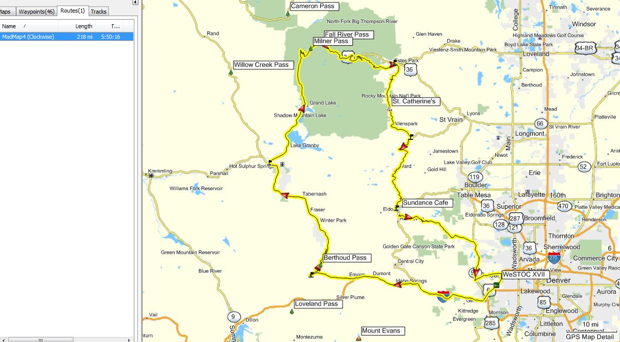
MadMap Ride 4 - Rocky Mountain National Park - 215 Miles
You'll be climbing thousands of feet in a matter of minutes as you enjoy the postcard panoramas from the Trail Ridge Road. There may be gold in them thar creeks alongside the Peak to Peak Scenic Byway where the Aspens cloak the hills in a vivid patchwork of autumnal hues.
Attractions: Tour the grand halls of the Stanley Hotel, best known for its haunting presence in Stephen King's "The Shining". Remember that "all work and no play makes Jack a dull boy" so be sure to take the time to explore the great outdoors of Rocky Mountain Park.
MadMap Ride 5 - Poudre Canyon and North Park - 301 Miles
 Once you've put a few miles of Interstate behind you, the rest of the ride is rugged
ranges and wide-open spaces through the beautiful Poudre Canyon, into North Park and over the Berthoud Pass. Feel what it's like to ride the wilderness.
Once you've put a few miles of Interstate behind you, the rest of the ride is rugged
ranges and wide-open spaces through the beautiful Poudre Canyon, into North Park and over the Berthoud Pass. Feel what it's like to ride the wilderness.
Warnings: Road hazards include sand and sometimes snow. Large stretches of CO 125 are open range so look out for animals. Check weather conditions before starting this ride and consider packing extra gear. Check your fuel in Walden; it's a bit far to the next pump.
Attractions: Relax with a meal and some live entertainment at the Mishawaka Amphitheatre in Bellevue.
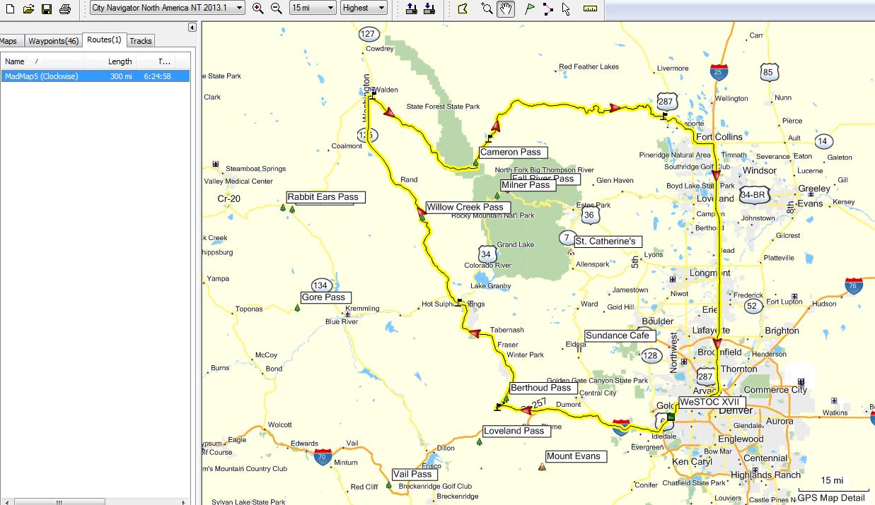
Garmin Mapsource File with all Rides
(version 1.1)
Route Map jpg files
(version 1.1)
NOTE!! The GPS routes available above were created using Garmin's Mapsource program and the City Navigator North America NT2013.10 map database. If you have an earlier version of City Navigator, or if you own a different gps, or use a different map set with your gps, you must verify these routes before using them!! Due to differences in the various map sets, you <may> get a slightly different route when using the provided routes!! To verify the route, load it into Mapsource, double click on the desired route in the route list, and select 'recalculate route'. Mapsource will then use the route waypoint data and your map database to create the route. <Sometimes> the route you get can vary from the desired route due to differences in the various map databases. Carefully compare the route you get with the routes above. If you do see a deviation from the desired route simply right click on the route and select 'insert route section', then pick a point on the desire road. Mapsource will modify the route to include that road section. You can then upload the route into your gps. The verification process is an important step if you are using any other mapset!. Even if you upload these routes into a different gps and they <look> correct, be wary! The first time the gps <thinks> you're off route it will perform a recalculation of the route and <may> change the route to <something> different!!